Photographers In Space
NASA have a flickr account because they have access to a unique location have filled it with some amazing photos, taken by their astronauts, of the work they do up there. The photos in the below gallery belong to a Flickr set caller ‘Gravity’ perhaps inspired by the recent film of the same name. The images really show off the breathtaking environment the astronauts work in. NASA has, in line with it’s brief of education, given detailed descriptions of each of the shots in their account, of you’re interested in astro photography or life above our atmosphere be sure the have a look about their Flickr account
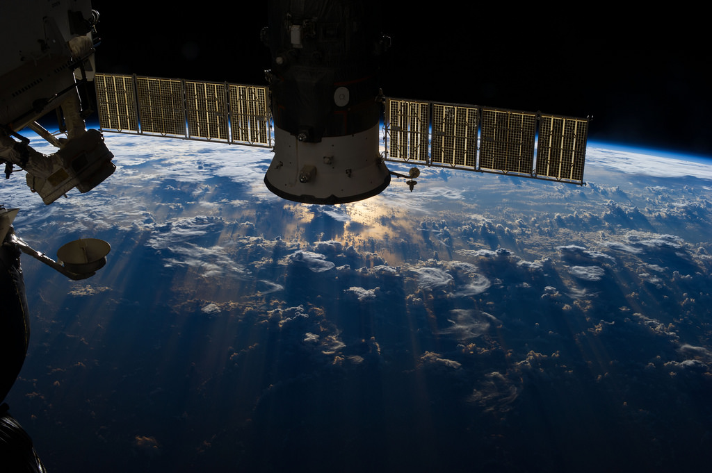
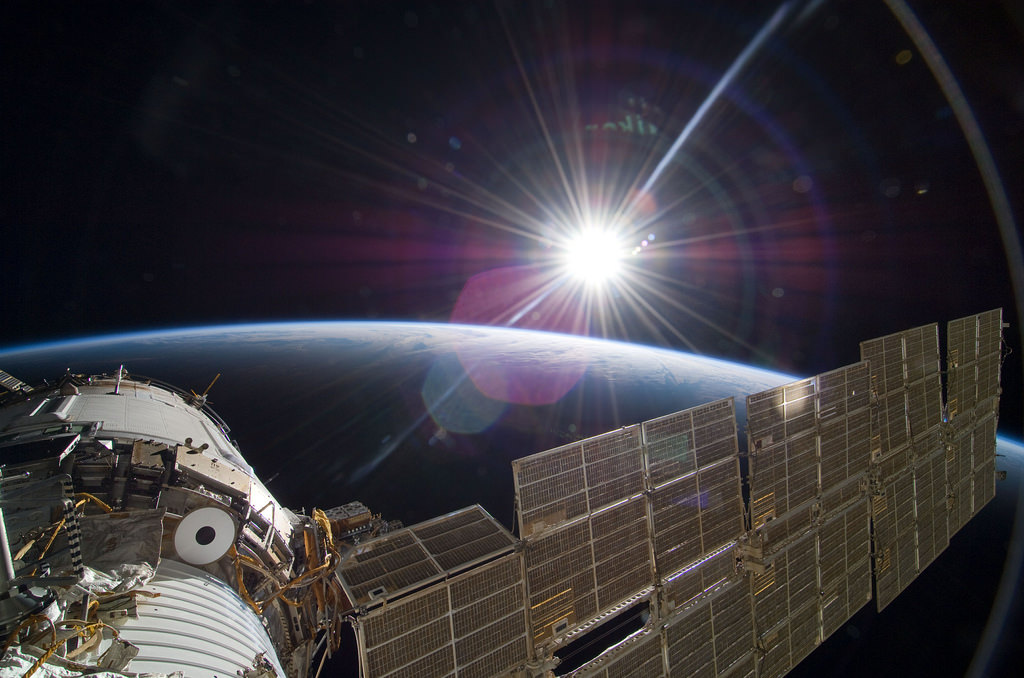 S129-E-007592 (22 Nov. 2009) — The bright sun greets the International Space Station in this Nov. 22 scene from the Russian section of the orbital outpost, photographed by one of the STS-129 crew members.
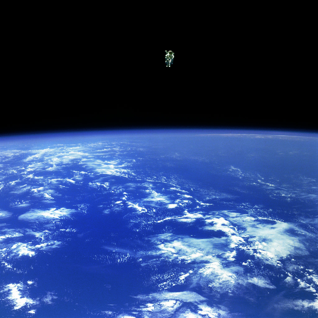 Mission Specialist Bruce McCandless II, is seen further away from the confines and safety of his ship than any previous astronaut has ever been. This space first was made possible by the Manned Manuevering Unit or MMU, a nitrogen jet propelled backpack. After a series of test maneuvers inside and above Challenger’s payload bay, McCandless went “free-flying” to a distance of 320 feet away from the Orbiter. This stunning orbital panorama view shows McCandless out there amongst the black and blue of Earth and space. (02/12/1984)
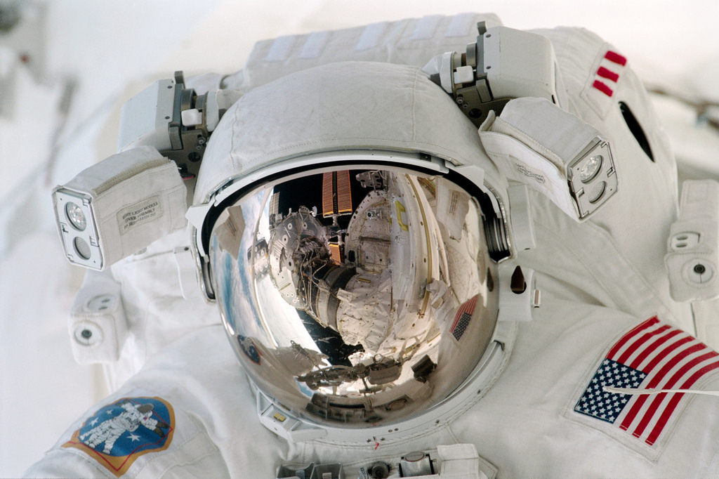
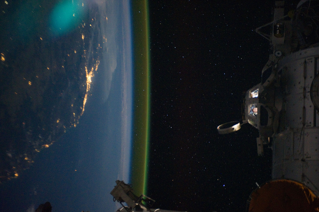 This unique photographic angle, featuring the International Space Station’s Cupola and crew activity inside it, other hardware belonging to the station, city lights on Earth and airglow was captured by one of the Expedition 28 crew members. The major urban area on the coast is Brisbane, Australia. The station was passing over an area southwest of Canberra.
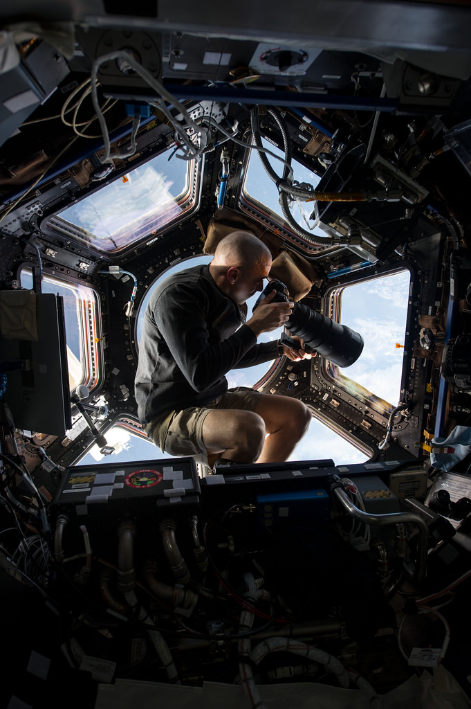 Inside the Cupola, NASA astronaut Chris Cassidy, an Expedition 36 flight engineer, uses a 400mm lens on a digital still camera to photograph a target of opportunity on Earth some 250 miles below him and the International Space Station. Cassidy has been aboard the orbital outpost since late March and will continue his stay into September.
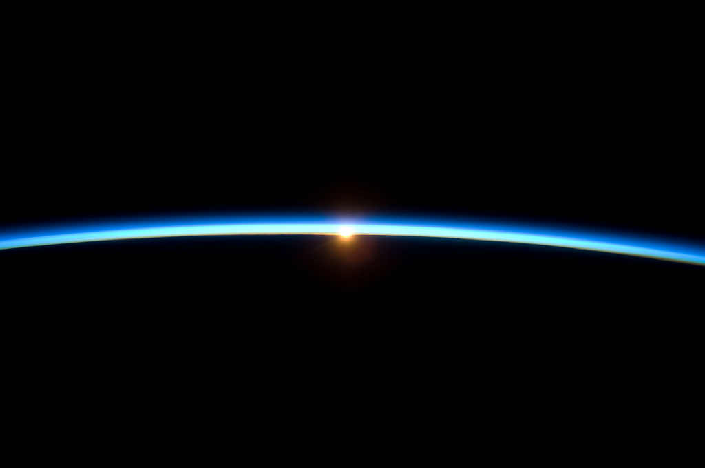 The thin line of Earth’s atmosphere and the setting sun are featured in this image photographed by a crew member on the International Space Station while space shuttle Atlantis (STS-129) remains docked with the station. 11/23/09
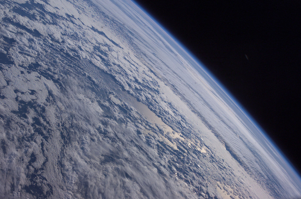 Earths horizon against the blackness of space is featured in this image photographed by an Expedition 7 crewmember onboard the International Space Station (ISS) on October 4, 2003
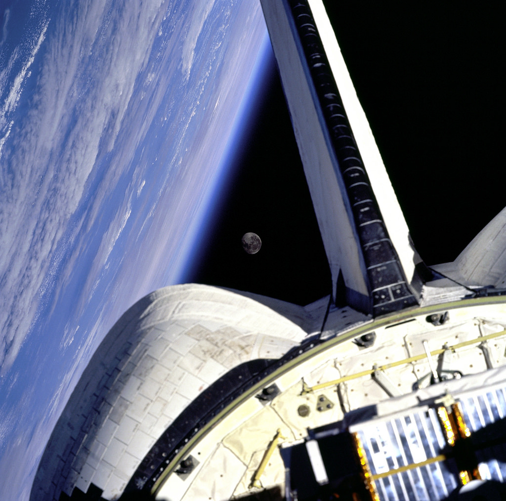 Earth and its Moon are nicely framed in this image taken from the aft windows of the Space Shuttle Discovery in 1998. Discovery – on mission STS-95 – was flying over the Atlantic Ocean at the time this image was taken.
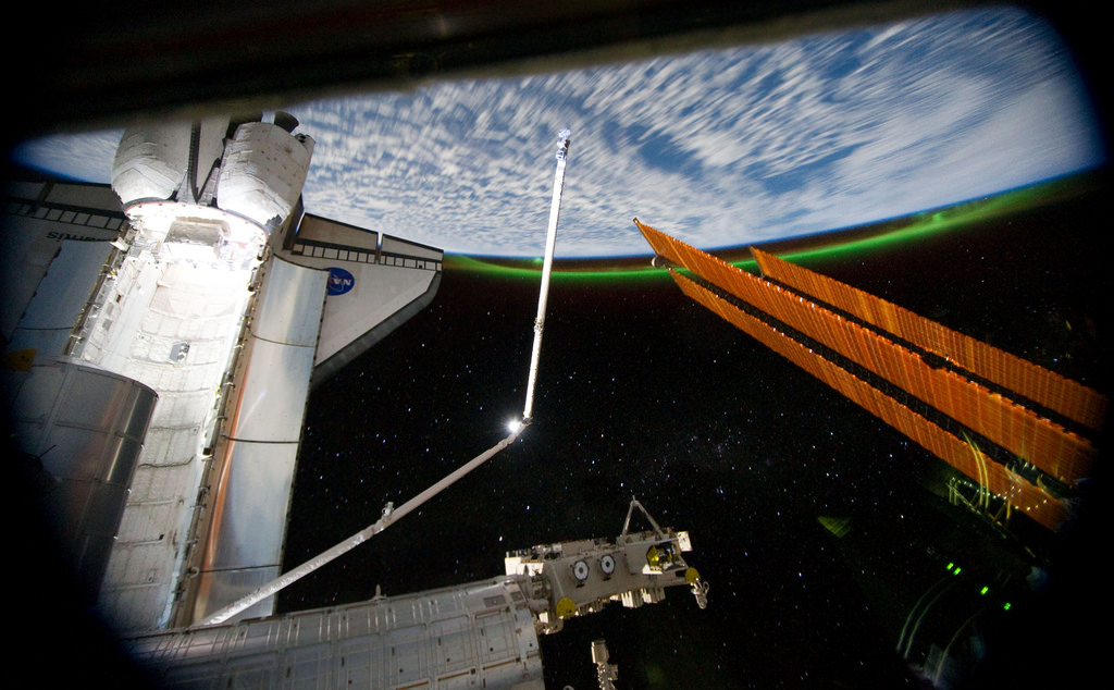 This panoramic view, photographed from the International Space Station, looking past the docked space shuttle Atlantis’ cargo bay and part of the station including a solar array panel toward Earth, was taken on July 14 as the joint complex passed over the southern hemisphere. Aurora Australis or the Soutern Lights can be seen on Earth’s horizon and a number of stars are visible also. Among Atlantis’s final contributions to the ISS is the Robotic Refueling Mission, developed at Goddard Space Flight Center. Atlantis brought this module to the International Space Station, where it will provide key support in maintaining future spacecrafts for years to come. STS-135 astronauts traveled to Goddard to complete special training for these robotics, a major component of the final shuttle mission. RRM is one of dozens of Goddard payloads to travel aboard orbiters into space throughout the 30-year flight history of the Shuttle Program. ISS028-E-016368 (14 July 2011)
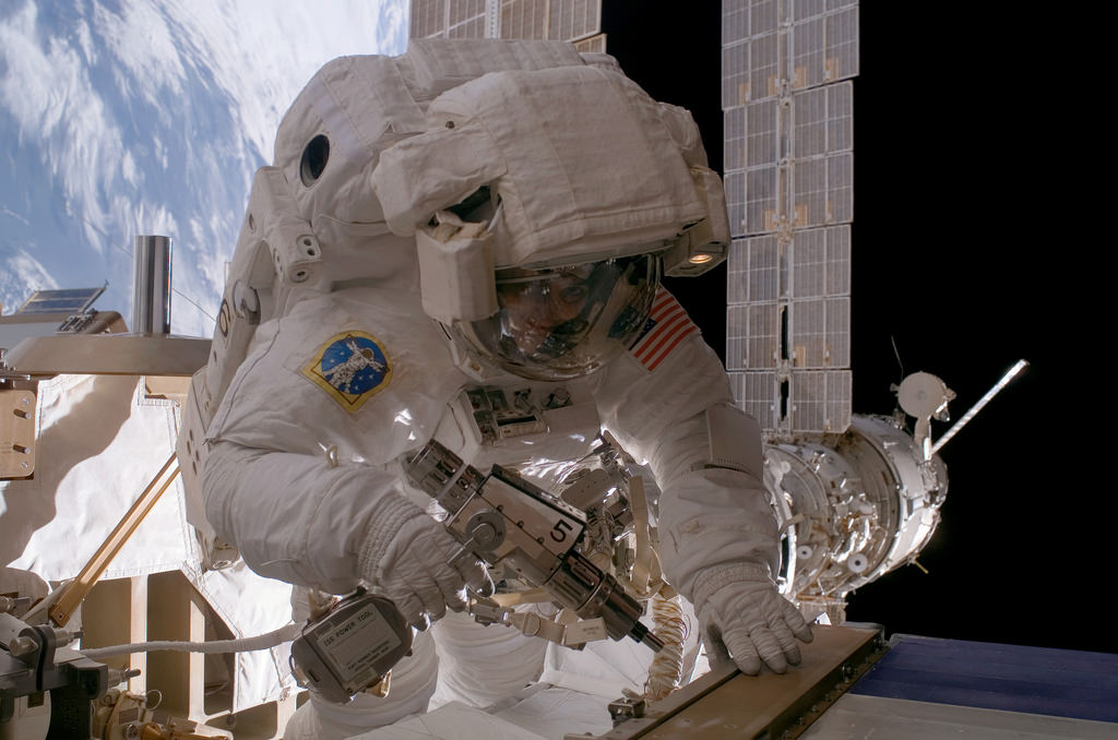 Astronaut Sunita L. Williams, Expedition 14 flight engineer, used a pistol grip tool as she worked on the International Space Station in the first of three spacewalks slated to occur over a nine-day period. During the 7-hour 55-minute spacewalk that took place on Jan. 31, 2007, Williams and station commander Michael E. Lopez-Alegria (out of frame) reconfigured one of two cooling loops for the Destiny laboratory module, rearranged electrical connections and secured the starboard radiator of the P6 truss after retraction.
 The city lights of Spain and Portugal define the Iberian Peninsula in this photograph from the International Space Station (ISS). Several large metropolitan areas are visible, marked by their relatively large and brightly lit areas, including the capital cities of Madrid, Spain—located near the center of the peninsula’s interior—and Lisbon, Portugal—located along the southwestern coastline. The ancient city of Seville, visible to the north of the Strait of Gibraltar, is one of the largest cities in Spain. The astronaut view is looking toward the east, and is part of a time-lapse series of images. The network of smaller cities and towns along the coastline and in the interior attest to the extent of the human presence on the Iberian landscape. The blurring of city lights is caused by thin cloud cover (image left and center), while cloud tops are dimly illuminated by moonlight. Though obscured, the lights of France are visible near the horizon line on the upper left, while the lights of northern Africa are more clearly discernable at right. The faint gold and green line of airglow—caused by ultraviolet radiation exciting the gas molecules in the upper atmosphere—parallels the horizon (or Earth limb). The Iberian Peninsula is the southwestern-most of the European peninsulas (together with the Italian and Balkan peninsulas), and includes the Principality of Andorra, as well as the Kingdom of Spain and the Portuguese Republic. The approximately 590,000 square kilometer landmass is bounded by the Atlantic Ocean to the northwest, west, and southwest and the Mediterranean Sea to the east. Its northeastern boundary is marked by the Pyrenees mountain range. Astronaut photograph ISS030-E-10008 was acquired on December 4, 2011, with a Nikon D3S digital camera using a 24 mm lens, and is provided by the ISS Crew Earth Observations experiment and Image Science & Analysis Laboratory, Johnson Space Center. The image was taken by the Expedition 30 crew. The image has been cropped and enhanced to improve contrast. Lens artifacts have been removed. The International Space Station Program supports the laboratory as part of the ISS National Lab to help astronauts take pictures of Earth that will be of the greatest value to scientists and the public, and to make those images freely available on the Internet. Additional images taken by astronauts and cosmonauts can be viewed at the NASA/JSC Gateway to Astronaut Photography of Earth. Caption by William L. Stefanov, Jacobs Technology/ESCG at NASA-JSC. Instrument: ISS – Digital Camera
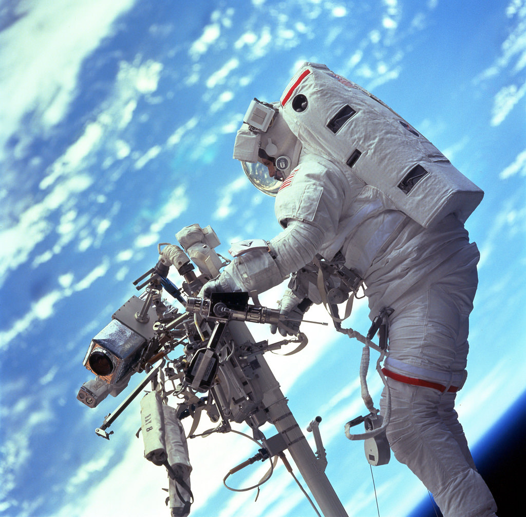 STS103-701-047 (19-27 December 1999) — Astronaut Steven L. Smith, payload commander, retrieves a power tool while standing on the mobile foot restraint at the end of the remote manipulator system (RMS). Many of the tools required to service the Hubble Space Telescope are stored on the handrail attached to the RMS visible in the photograph.
 Beautiful Earth and NASA’s Space Shuttle Atlantis (STS-71), July 2, 1995 at 11:40:12 GMT As Seen From the Russian Federation Mir Space Station Latitude (LAT): 44.6 · Longitude (LON): 37.0 · Altitude (ALT): 210 Nautical Miles · Sun Azimuth (AZI): 240° · Sun Elevation Angle (ELEV): 57°
 One of the Expedition 36 crew members aboard the International Space Station used a 50mm lens to record this image of a large mass of storm clouds over the Atlantic Ocean near Brazil and the Equator on July 4, 2013. A Russian spacecraft, docked to the orbiting outpost, partially covers a small patch of sunglint on the ocean waters in a break in the clouds.
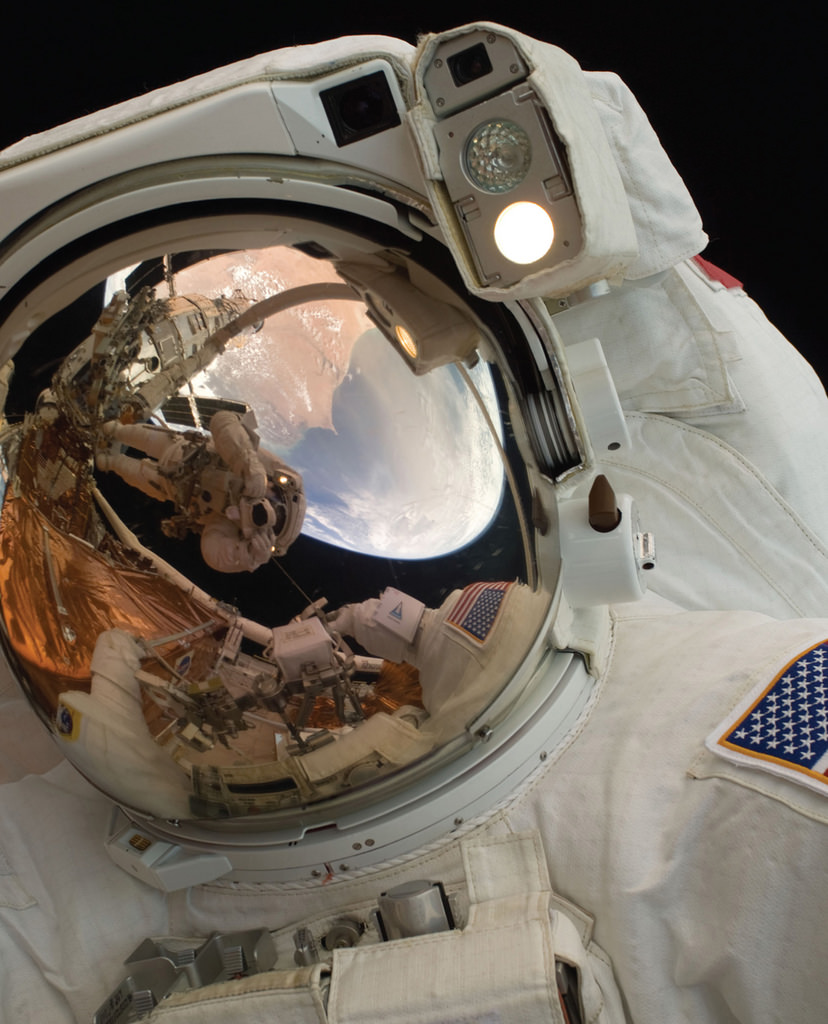 A close-up of Astronaut John Grunsfeld shows the reflection of Astronaut Andrew Feustel, perched on the robotic arm and taking the photo. The pair teamed together on three of the five spacewalks during Servicing Mission 4 in May 2009.
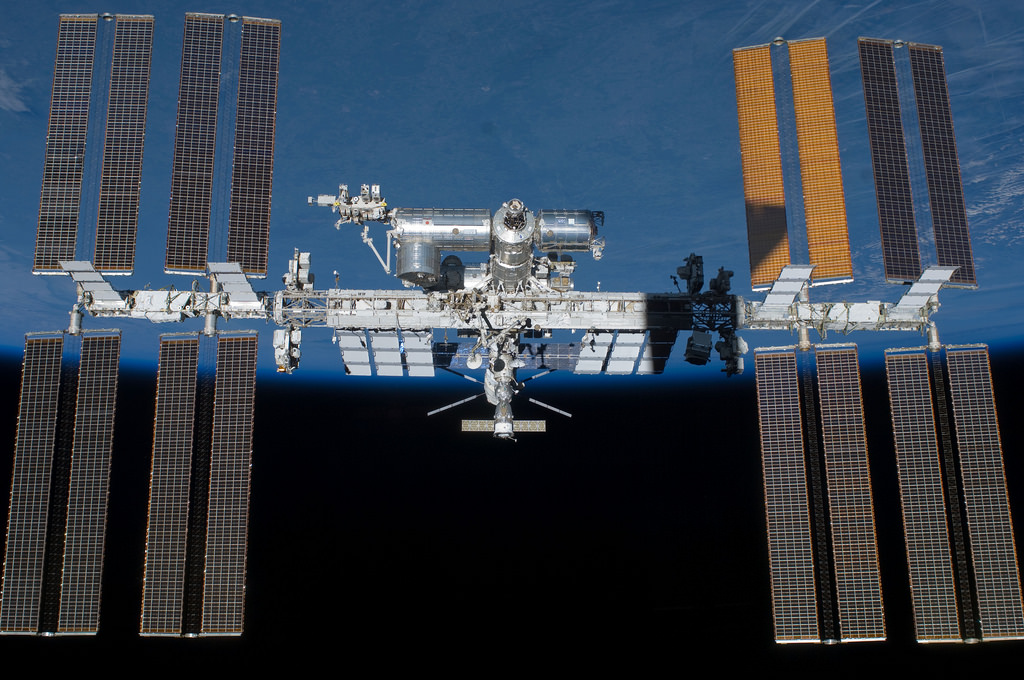 S134-E-010590 (29 May 2011) — Backdropped by Earth’s horizon and the blackness of space, the International Space Station is featured in this image photographed by an STS-134 crew member on the space shuttle Endeavour after the station and shuttle began their post-undocking relative separation. Undocking of the two spacecraft occurred at 11:55 p.m. (EDT) on May 29, 2011. Endeavour spent 11 days, 17 hours and 41 minutes attached to the orbiting laboratory
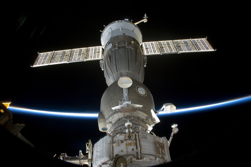 View of Soyuz Spacecraft docked to the International Space Station (ISS). Earth limb is visible in the background. Photo was taken during STS-127 / Expedition 20 Joint Operations.
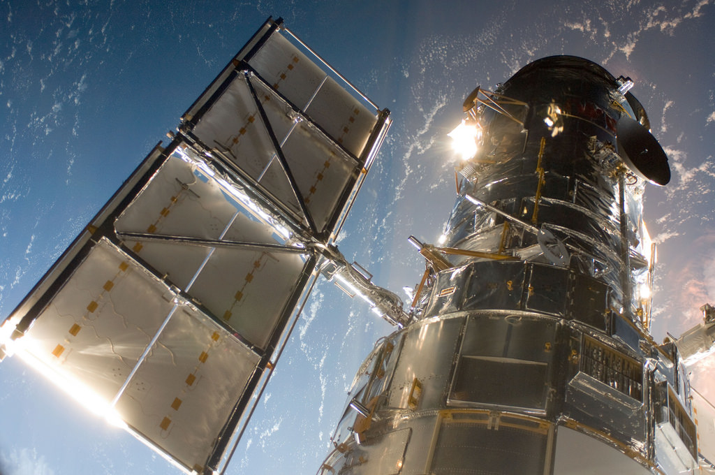 The Hubble Space Telescope in a picture snapped by a Servicing Mission 4 crewmember just after the Space Shuttle Atlantis captured Hubble with its robotic arm on May 13, 2009, beginning the mission to upgrade and repair the telescope.
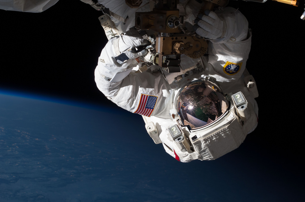
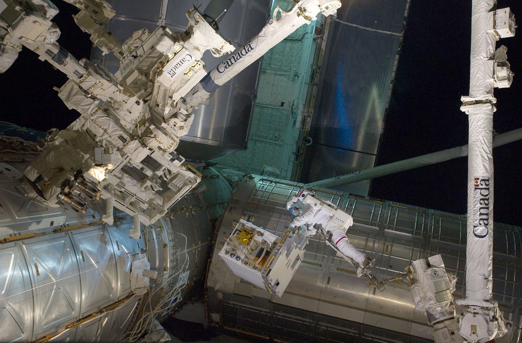
 Close views of Paul Richards during an Extravehicular Activity (EVA) on the International Space Station (ISS). View STS102-346-021 is a crew pick selection.
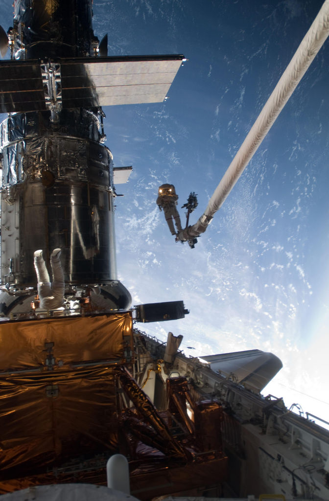 Mission Specialist John Grunsfeld is positioned on a foot restraint on the end of Atlantis’ remote manipulator system and Andrew Feustel (top center), mission specialist, participate in the mission’s fifth and final spacewalk.
 Ed White made the United States’ first spacewalk on 3 June 1965 during the Gemini 4 mission. The extra-vehicular activity (EVA) started at 19:45 UT (3:45 p.m. EDT) on the third orbit when White opened his hatch and used the hand-held manuevering oxygen-jet gun to push himself out of the capsule. The EVA started over the Pacific Ocean near Hawaii and lasted 23 minutes, ending over the Gulf of Mexico. Initially, White propelled himself to the end of the 8 meter tether and back to the spacecraft three times using the hand-held gun. After the first three minutes the fuel ran out and White manuevered by twisting his body and pulling on the tether. The photographs were taken by commander James McDivitt 19:54 UT (3:54 p.m. EDT) Over New Mexico
 A picturesque line of thunderstorms and numerous circular cloud patterns filled the view as the International Space Station (ISS) Expedition 20 crew members looked out at the limb (blue line on the horizon) of the Earth. The region shown in the astronaut photograph (top image) includes an unstable, active atmosphere forming a large area of cumulonimbus clouds in various stages of development. The crew was looking west-southwest from the Amazon Basin, along the Rio Madeira toward Bolivia when the image was taken. The semi-circular cloud patterns near the center of the astronaut photograph may be detected in a Geostationary Operational Environmental Satellite (GOES) infrared satellite image of the region (bottom image, yellow rectangle) acquired about 20 minutes earlier than the astronaut photograph. The distinctive circular patterns of the clouds in the astronaut photograph are likely caused by the aging of thunderstorms. Such ring structures often form during the final stages of storms’ development as their centers collapse. Sunglint—the mirror-like reflection of sunlight off a water surface directly back to the camera onboard the ISS—is visible on the waters of the Rio Madeira and Lago Acara in the Amazon Basin. Widespread haze over the basin gives the reflected light an orange hue. The Rio Madeira flows northward and joins the Amazon River on its path to the Atlantic Ocean. A large smoke plume near the bottom center of the image may be one source of the haze.
 Expedition 35 Flight Engineers Chris Cassidy (pictured) and Tom Marshburn (out of frame) completed a spacewalk at 2:14 p.m. EDT May 11, 2013 to inspect and replace a pump controller box on the International Space Station’s far port truss (P6) leaking ammonia coolant. The two NASA astronauts began the 5-hour, 30-minute spacewalk at 8:44 a.m. A leak of ammonia coolant from the area near or at the location of a Pump and Flow Control Subassembly was detected on Thursday, May 9, prompting engineers and flight controllers to begin plans to support the spacewalk. The device contains the mechanical systems that drive the cooling functions for the port truss.
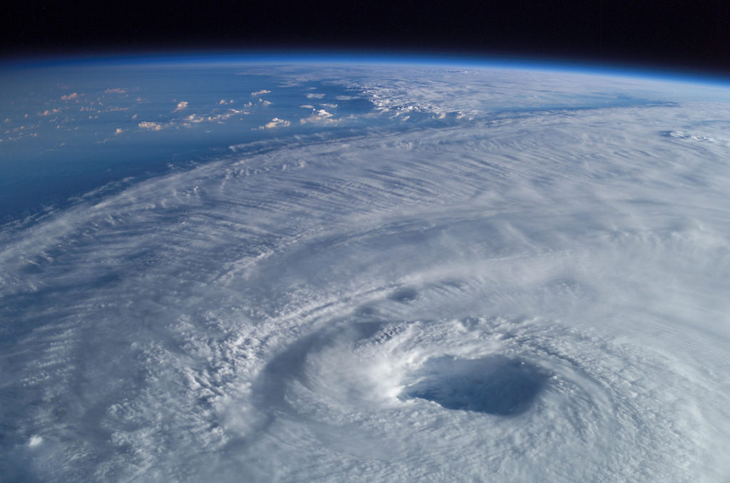 This close-up view of the eye of Hurricane Isabel was taken by one of the Expedition 7 crewmembers onboard the International Space Station (ISS). “It is quite interesting to look at storms, said Ed Lu, Expedition 7 science officer. “When you see a large cyclone, you can see the spiral structure, and you can actually see – if there is a hurricane – you actually see the eye of the hurricane. You can look right down into it if you are lucky enough to go right over the top.”
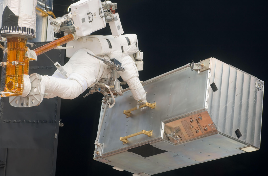 STS-125 Mission Specialist Andrew Feustel positioned on a foot restraint on the end of Atlantis’ remote manipulator system moves the Corrective Optics Space Telescope Axial Replacement (COSTAR) during the mission’s third session of extravehicular activity (EVA) as work continues to refurbish and upgrade the Hubble Space Telescope.
 Silhouetted against the Earth, Atlantis flies into the rising Sun in this photograph taken by an astronaut on the International Space Station on July 19, 2011. On July 20, the shuttle undocked from the station for the final time and began preparations to return home. During their 13 days in space, the shuttle astronauts supplied the International Space Station with a new logistics module, tested tools, technologies, and techniques to refuel satellites in space, and collected old equipment from the space station. Atlantis is scheduled to land at Kennedy Space Center at 5:56 a.m. local time on July 21, concluding NASA’s 30-year space shuttle program. In addition to the science the shuttle and earlier programs enabled, human space flight has given us a unique view of planet Earth, which includes the now iconic spectacle of Earth rising over the Moon taken during the first lunar landing on July 20, 1969, and the photographs taken from Atlantis during its last full day in space on July 20, 2011. In fact every flight is a mission to planet Earth, as described in the Earth Observatory’s tribute to the shuttle program. Observing Earth from space is one of the NASA’s longest-standing science experiments. Astronauts have used handheld cameras to photograph the Earth since the Mercury missions in the early 1960s, taking more than 800,000 photographs of Earth. Half of that total has come from the 135 flights of the Space Shuttle program. “Astronauts are like tourists going to an exotic place, and we know they are going to take photos,” said Kam Lulla. “Early in the space program, NASA decided that if they were going to do this anyway, let’s get some science content out of it.” That was a wise decision. Astronauts are still being trained for the view from space. The Space Shuttle program is ending, but the International Space Station offers its own vantage point of the planet—and astronauts will still be heading there for another decade. Astronaut photograph ISS028-E-017845 was acquired on July 19, 2011, and is provided by the ISS Crew Earth Observations experiment and Image Science & Analysis Laboratory, Johnson Space Center. The image was taken by the Expedition 28 crew. The image has been cropped and enhanced to improve contrast. The animation has been motion-stabilized. The International Space Station Program supports the laboratory as part of the ISS National Lab to help astronauts take pictures of Earth that will be of the greatest value to scientists and the public, and to make those images freely available on the Internet. Additional images taken by astronauts and cosmonauts can be viewed at the NASA/JSC Gateway to Astronaut Photography of Earth.
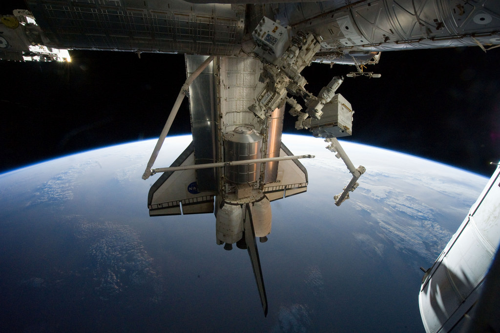
 With his feet secured on a restraint on the space station remote manipulator system’s robotic arm or Canadarm2, NASA astronaut Mike Fossum (frame center) holds the Robotics Refueling Mission payload, which was the focus of one of the primary chores accomplished on a six and a half hour spacewalk on July 12. The failed pump module is with DEXTRE on left side of the photo. NASA astronauts Fossum and Ron Garan performed the six-hour, 31-minute spacewalk, which represents the final scheduled extravehicular activity during shuttle missions.
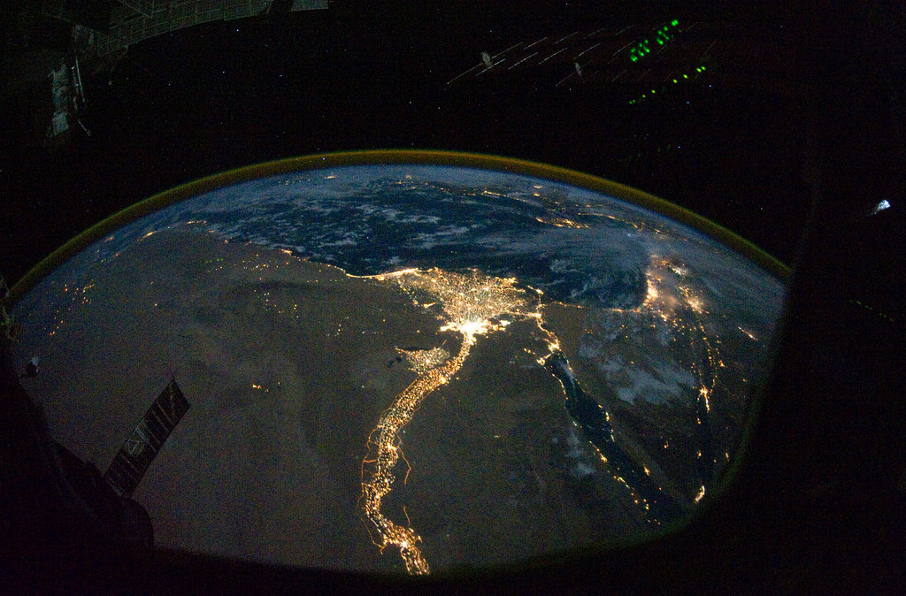
From 220 miles above Earth, one of the Expedition 25 crew members on the International Space Station took this night time photo featuring the bright lights of Cairo and Alexandria, Egypt on the Mediterranean coast. The Nile River and its delta stand out clearly as well. On the horizon, the airglow of the atmosphere is seen across the Mediterranean. The Sinai Peninsula, at right, is outlined with lights highlighting the Gulf of Suez and Gulf of Aqaba.
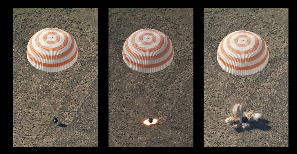
This montage of three frames shows the Soyuz TMA-17 spacecraft as it lands with Expedition 23 Commander Oleg Kotov and Flight Engineers T.J. Creamer and Soichi Noguchi near the town of Zhezkazgan, Kazakhstan on Wednesday, June 2, 2010. NASA Astronaut Creamer, Russian Cosmonaut Kotov and Japanese Astronaut Noguchi are returning from six months onboard the International Space Station where they served as members of the Expedition 22 and 23 crews.
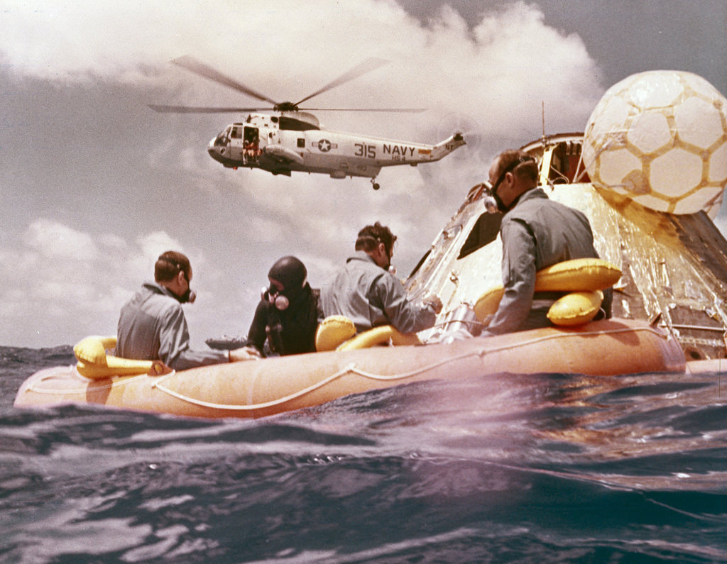
Sitting in the life raft, during the Apollo 12 Pacific recovery, are the three mission astronauts; Alan L. Bean, pilot of the Lunar Module (LM), Intrepid; Richard Gordon, pilot of the Command Module (CM), Yankee Clipper; and Spacecraft Commander Charles Conrad. The second manned lunar landing mission, Apollo 12 launched from launch pad 39-A at Kennedy Space Center in Florida on November 14, 1969 via a Saturn V launch vehicle. The Saturn V vehicle was developed by the Marshall Space Flight Center (MSFC) under the direction of Dr. Wernher von Braun. The LM, Intrepid, landed astronauts Conrad and Bean on the lunar surface in what?s known as the Ocean of Storms, while astronaut Richard Gordon piloted the CM, Yankee Clipper, in a parking orbit around the Moon. Lunar soil activities included the deployment of the Apollo Lunar Surface Experiments Package (ALSEP), finding the unmanned Surveyor 3 that landed on the Moon on April 19, 1967, and collecting 75 pounds (34 kilograms) of rock samples. Apollo 12 safely returned to Earth on November 24, 1969
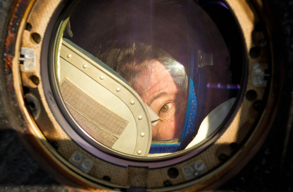
Expedition 27 Flight Engineer Cady Coleman peeks out of a window of the Soyuz TMA-20 spacecraft shortly after she and Commander Dmitry Kondratyev and Flight Engineer Paolo Nespoli landed southeast of the town of Zhezkazgan, Kazakhstan, on Tuesday, May 24, 2011. NASA Astronaut Coleman, Russian Cosmonaut Kondratyev and Italian Astronaut Nespoli are returning from more than five months onboard the International Space Station where they served as members of the Expedition 26 and 27 crews
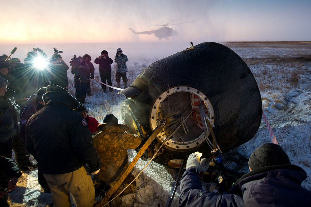
Russian support personnel work to help get Expedition 29 crew members out of the Soyuz TMA-02M spacecraft shortly after the capsule landed with Expedition 29 Commander Mike Fossum, and Flight Engineers Sergei Volkov and Satoshi Furukawa in a remote area outside of the town of Arkalyk, Kazakhstan, on Tuesday, Nov. 22, 2011. NASA Astronaut Fossum, Russian Cosmonaut Volkov and JAXA (Japan Aerospace Exploration Agency) Astronaut Furukawa are returning from more than five months onboard the International Space Station where they served as members of the Expedition 28 and 29 crews

Kim is a professional photographer & Official Fujifilm X-Photographer living in Celbridge Co Kildare, Ireland. When not shooting Portraits and Weddings or Corporate & Editorials he can be found searching out the best coffee shops or running round after his two kids.
Get 20% off Unlimited Photo Storage & Galleries with Smugmug | Download Capture One Fujifilm